Wednesday, November 30, 2011

Week 3: Panama to Costa Rica

Two weeks may have been enough, though we so looked forward to Costa Rica.  Just became tired of socializing, eating, scheduling, confinement...you get the picture!  There were many excursions and land tours from our anchorage in various beautiful locations but all were very expensive.  The ship's currency is the Euro, so not favorable to Americans.  We often found that going ashore and bargaining with taxi drivers was a lot cheaper, and more fun to do on our own.  Our last week's itinerary proved to be quite nice in spite of our waning enthusiasm!

Leaving Panama on the southwest Pacific, we first stopped at Isla Iguana,  a beautiful little island about 7 km or 4.5 miles off the coast of Panama, a Wildlife Refuge surrounded by palm trees, fine white sand beaches, and crystal clear waters, perfect for snorkeling the coral reefs.  There appeared to be a small, private hostel for a few overnight guests.  Frigate birds were in abundance and the fishing was said to be terrific.

Ashore for snorkeling on Isla Iguana


The epitome of a cruise photo (says Beth)

Howard in his element
Our next stop was Isla Gamez, one of the many uninhabited islands located in the Chiriqui Gulf National Marine Park, near the border with Costa Rica.  The extensive coral reef and mangrove swamps serve as protected areas for leatherback turtles and many species of exotic fish.  The beautiful beaches are lined with coconut palms.  Our naturalist, Steffi, who joined us in Panama, proceeded to open a fallen coco for us that she found on the beach.  She gives talks a couple of times a day on the flora and fauna of our destinations in Costa Rica.


Golfito is a remote and secluded town on the southern Pacific mainland coast, not far from the border with Panama.  A major port until the mid 80s, Golfito was the center for the banana growing region, with the United Fruit Company's headquarters being based here.  Since its closure the town has suffered from major economic loss but with the advent of tourism, is slowly rebuilding itself.

We looked forward to the day ashore, first just sitting at the marina bar with a beer and free wifi.  The ship's wifi is 20 Euros for 3 hours, or about $9 an hour!  Next we walked the short distance into town and found a Farmacia for some throat lozenges as I seem to be coming down with a sore throat or something.

We wanted local  Tico food for lunch and the pharmacist recommended the perfect restaurante.  We had hamburgers and French fries...hamburguesas con papas fritas!  Every small Central American country has their own national beer.  Here in Costa Rica it is Imperial.  In Belize, it is Belikin and in Honduras, Salva Vida.


Picturesque Golfito


Golfito fishing fleet

Nice view from town


All aboard...though this is not the ship's tender

Approaching Drake Bay we seemed to have magically entered the rainy season as we were hit by a deluge.  A good reason to stay aboard and while the hours away reading.  The groups that had pre-paid "horseback riding to the last frontier" and a hike through Corcovado National Park returned 4 hours later drenched to the bone.  Many tender or inflatable trips to shore warn of wet landings, meaning you usually disembark in the water or surf, but this wet landing took on a stronger meaning!

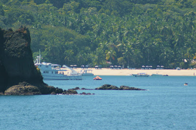
By the time we reached Quepos we almost felt at home, having visited this area and stayed for a week in 2004.  Instead of paying the 44 Euros per person, or $120 for the two of us, to visit Manuel Antonio National Park, we just hired a taxi when we got into port:  $30 round-trip for the taxi and $20 for park admittance for two.  After hiking around for awhile, and yes seeing a monkey...though the photo is blurry, we paid a few extra dollars or colones (500 = $1) for cold Imperials.  Oh, and taxi drivers don't let you out of their sight so no worries about him being there for the return trip!

See the monkey?

A taxi to Manuel Antonio..much cheaper than ship tour

Banana plants

The beach at sunset
Please click on Isla Tortugas to get more info on our last stop for snorkeling or a paid nature walk at the private Curu Wildlife reserve.  We stayed onboard and began organizing and packing after 3 weeks of being spread out in closets and cabinets,  for tomorrow's arrival at Puerto Caldera and our point of disembarkation.  We did admire the view of Isla Tortugas where there were many day-cruise boats ferrying passengers to and fro'. 

Isla Tortugas from a zoom lens


 So dear friends, by the time you read this we will be enjoying 4 days of "decompression" at a condo in Jaco, Costa Rica.

Tuesday, November 22, 2011

Panama Canal Transit


The creation of a water passage across Panama was one of the supreme human achievements of all time, the culmination of more than 20 years of phenomenal effort and sacrifice.  No statistics of tonnage or tolls can begin to convey the grandeur of what was accomplished, bridging the divide and bringing people together.

We arrived at Colon on the Caribbean side of the Panama Canal at about 5:30 a.m., awakened by bright red and green lights flashing in our porthole.  Any further sleep became impossible as we were so excited for this day’s experience, transiting the Panama Canal.  Our ship was boarded by the official pilot who guided us through the locks, as well as six line handlers, and our very own interpretive commentator who explained history, engineering, and geology, with a little local humor thrown in. 

The 50 mile passage between Colon and Panama City, or actually Balboa, took us approximately 9 hours, getting underway at 7 a.m. and arriving at our anchorage around 4:30 p.m.  We rose 82 feet in a series of 3 locks, being pulled along by “mules” or small, powerful rail cars, going up to Gatun Lake.  Crossing the huge lake took 2 hours, seeing the large dam which controls the water level, jungle-covered islands, and marine traffic both incredibly large to small sail boats.  Coming up on the continental divide we pass under the Centennial Bridge, as our entrance into the Pacific side of the divide brings on a deluge of rain.


Lunch buffet is served on deck in the Tropical Bar so we can view the scenery, damp and drizzly though it is.  Our early rising makes us very sleepy after lunch and with the rain soaking the sun deck, we retire to our cabin and watch the down-hill ride through the Miraflores locks through our porthole window.  

The approach of the Bridge of the Americas, which we have anticipated all day, brings us all back on deck with various degrees of rain gear.  The excitement is generated by the fact that our ship’s highest mast is 67 meters tall, and the bridge measures 63 meters at mean tide.  Low tide is at 3:34 p.m., EST, and we slow to a crawl as it looms ahead, waiting for the magic time.  This is Captain Peter’s first crossing as well, and he teases us with grimaces and hand signs, indicating a crash is imminent.  We pass under with maybe a meter to spare!


Surprisingly, we anchor upon arrival outside of the Balboa harbor, with a beautiful view of the Panama City skyline across the bay.  We had thought we would be docking alongside a pier since all but 20 of us will be disembarking in the morning and in the late afternoon we will take on another 120 passengers for the trip to Costa Rica and Nicaragua.  This has to be accomplished by tender.  We decided not to venture ashore as conditions were very rocky and boarding the tender looked treacherous, at best!

San Blas Islands, Panama


We spent another full day at sea sailing from Cartagena to the San Blas Islands, some 180+ nautical miles.  The San Blas, an archipelago of 365 islands, runs along the Caribbean coast of Panama and borders Colombia and the Darien Province.

 About 36 of the islands are inhabited by the indigenous Kuna people, an autonomous territory in Panama.  Special permission, granted by the tribe chief or El Jefe, was required for our ship and its passengers to enter and visit the islands.  El Jefe and his family came aboard to collect the ship’s fee and present a special display of their culture’s wares and colorful molas. 

We were allowed to visit two islands, one for a village experience and one for snorkeling and swimming.  The village was named Cartisugdub according to the welcome sign.  It consisted of many primitive thatched and framed houses, community meeting places, and even schools.  The vendors were plentiful, selling their handmade clothing and molas which are much like place mats or possibly wall hangings, and usually feature bright woven birds or fish designs. 

Nothing was negotiable though we bought a pair of molas that seemed of better quality than others we saw, for $20.  Photos cost a dollar or two and everyone, including their pet monkeys, will pose for a fee.

It was extremely hot and humid; the first time the heat has really gotten to me.  We were quite ready to return to the ship’s air conditioning after about 45 minutes of walking the dirt streets and paying for pictures and admiring the crafts. 

The snorkeling trip sounded less and less appealing as the afternoon heat gathered, and we became comfortable sipping a cold Corona.  Remember that most of our trips ashore require walking down the steep gang plank and being assisted into the rolling tender for perhaps a 10-15 minute boat ride to our destination!  Not always an alluring choice…

Friday, November 18, 2011

Cartagena, Colombia

After two glorious days at sea, we arrived at what was certainly one of the highlights of this trip...Cartagena, Colombia. This is a blurb from the ship's daily update of ports of call, in this case obviously Cartagena.


Cartagena de Indias is the capital of the Bolivar Province.  The metropolitan area has a population of 1,240,000.  It is the fifth largest urban area in Colombia.  Today the city is a center of economic activity in the Caribbean region and a popular tourist destination.

Cartagena’s walled city and fortress were designated a UNESCO World Heritage Site in 1984.  Hot, sultry, filled with the sounds of music and bright with color and tradition, Cartagena de Indias has been an important port on the Caribbean since it was founded in 1533.  Gold and silver left the port bound for Europe, pirates looted the city, and a walled fort grew to protect both shipping and the slave trade.  Its colonial charm and the old walled city, the Ciudad Amarullada, with tiled roofs, balconies and flower-filled courtyards, beckons visitors to stroll the narrow streets of to enjoy a weekend getaway.
Cartagena’s cathedral, with its massive exterior, simple interior and fortress appearance was begun in 1575, partially demolished by Sir Francis Drake’s cannons, and then completed in 1602.  The Iglesia de Santo Domingo, which is little changed from colonial days, is the oldest church in the city, and like the cathedral, was built to resist invaders. 

The Castillo de San Felipe de Barajas is the largest of a series of fortresses built to protect the city from pirates.  A must-see is the tunnel system meant to facilitate supply and evacuation of the fortress.


 We joined some friends for our own excursion into the city, as opposed to the ship's tour.  Our main points of interest were the old fort, San Felipe de Barajas, and the old walled city.  We hope you enjoy Cartagena from our point of view!


Thursday, November 17, 2011

Two Days at Sea


Leaving Aruba, we were two days at sea.  Life onboard took on a different perspective; lazy and laid-back, less structured, though there were activities.  Not being one for most group things, I found myself joining in the morning aerobics and stretches. There was also mast climbing for those brave souls who, unlike me, are not afraid of heights!

Activities include climbing the mast

 Our Captain, Peter Kaaling, had story-telling times where he regaled us with tales of his adventures at sea aboard the Gotheburg, a sailing replica of the 18th century Swedish East Indiaman.  It is the world's largest wooden sailing vessel. His journey was almost 18 months, leaving from Gothenburg, Sweden and sailing around the Cape of Good Hope in Africa, then 5000 miles to Australia where he turned off the engines and swore to sail the entire way…and did.  His crew of 80 was a combination of experienced sailors and volunteers. They continued on to China, with stops at Hong Kong and Singapore, then returning to Sweden by way of the Suez Canal, welcomed by thousands of private boats and a hundred thousand spectators on shore.


Captain Kraaling regales us with tales of sea adventures
There was deck golf and water aerobics but mostly, for us anyway, it was grab a lounge chair on the sun deck and settle in for some reading on the Kindle, where we had downloaded a bunch of books before leaving.

A lot of reading on the sun deck
  Howard enjoyed the knot tying lessons by Xaverino, one of the line handlers. Phillip, the Cruise Director, always gave briefings on our next port of call…in this case Cartagena, where we will be arriving the morning of Wednesday the 16th.  There was also a modified “man overboard” drill by the sports team.

A modified man overboard drill by the sports team

Phillip, our Cruise Director, briefs us on next port of call

Captain oversees the sail and line handlers
Thus go the days at sea, with a lot of very good food and drink, and nightly entertainment thrown in for good measure. 

Sunday, November 13, 2011

Aruba, Bonaire, and Curacao...The ABC Islands

 Bonaire is 50 miles north of Venezuela and the second largest, quietest and least known of the islands of the Dutch Antilles, with Kralendijk as its capital.  The island is semi-arid with an 18 mile coral reef that offers spectacular diving.  Along the shore strong waves crashing against volcanic rocks and coral have created ridges, unusual lava formations, grottoes, and caves.

Not being divers, we opted for the land tour.  Bonaire is covered with mostly desert vegetation, ranging from barren rocky hills and salt mines to green parklands and freshwater lakes with lots of bird-life.  The popular Flamingoes were not in residence on our drive, but we did see lots of the Amazon parrots.

We arrived in Willemstad, Curacao in the midst of the Heineken sailing regatta, where a time-out was called to allow the Star Flyer plenty of maneuvering space to make a “u-turn” in the middle of the harbor and dock alongside this beautiful town. 

The day was perfect for a long walk, which involved taking a free water taxi across the shipping canal which divides the town into “old” and “new”, to shop and take pictures.  The architecture is reminiscent of a Dutch town with its red roofs and pastel colors….very photogenic!

There is a colorful floating market on the waterfront in downtown Willemstad where merchants from Venezuela travel the 50 miles by boat to sell fresh fish and other produce directly from their vessels under an array of colorful awnings.  This picturesque location has been one of our favorites thus far, followed closely by Grenada and Barbados.

Sunday, November 13, 2011 we dock in Oranjestad, Aruba.  A walk into town quickly informed us that everything is closed, though a few photos were shot.  We thought perhaps a taxi drive to the beaches might be in order until the downpour of rain started and continued most of the day.  Reading and paying for internet use became the activities of the day. 

Oranjestad is the center and capital of Aruba.  The official language is Papiamento; sort of a mixture of Dutch, Spanish and English, also spoken in Bonaire.  The currency for all 3 islands is the US dollar.  Though Holland is part of the European Union the Euro is not used as it discourages U.S. tourism…smart people and good for us.  The ship’s currency is the Euro, however.

Rather than upload photos separately, I will link a slideshow to my Picasa album for Aruba, Bonaire and Curacao.  Other albums from this trip thus far can be viewed there as well.


For the next two days we will be at sea, arriving Cartagena, Columbia November 16th.   We will be back in touch whenever possible.  Quick updates will be posted to Facebook. 


Friday, November 11, 2011

Aboard the Star Flyer: Grenadines and Grenada

We said our ‘goodbyes’ to the excellent staff of Adulo Apartments.  Roger picked us up on schedule for the short drive to the ship terminal near Bridgetown for the 4 p.m.  embarkation; a long and hot procedure involving the individual processing of each passenger, 127 in all, including photos for our identification cards.  This gave us adequate time to meet several of our fellow shipmates.  We are a multi-national group, with an age range average of 50-70, with a few younger and some agile 80+ year olds.

Docked for departure from Barbados

Orientation by the Tropical Bar

The Star Flyer was an impressive sight docked alongside the pier.  As we boarded cocktails and hors d’oeuvres were served.  We wandered around admiring the casual elegance of the ship’s appointments.   Our stateroom is conveniently located on the Clipper Deck, near the dining room, and only one level down from the Tropical Bar and sun-decks.  Peter, our cruise director, gave a welcome orientation and introduced the staff.

 Dinner is served between 8-10 p.m.  There are several courses starting with appetizers, then soup and salads, and finishing with a selection of desserts. Our first night’s entrees included rack of lamb, duck breast, and a salmon fillet.  Baskets of bread and bottles of wine were plentiful.  It soon became quite evident that the meals were first class and the service excellent and personal. 

At 10 p.m. the sail-raising ceremony begins with all hands on deck and the music of "1492" filling the air as the sails are hoisted.  Our 22 day voyage aboard the Star Flyer begins as we head out for an overnight sail to the Grenadines.  Our room is very spacious, especially by motorhome standards.  The head and shower is much larger than we are used to and beautifully appointed.  The large porthole offers us a fabulous view of the Caribbean Sea and islands as we pass, though who spends much time in the room when aboard a boat like this!
Raising the sails

Participation not mandatory!


The Grenadines are a chain of approximately 600 small islands, with St. Vincent as the main island.  We anchored off Captain's Best Beach on Union Island.  Soon the ship's tender started ferrying guests to shore for an afternoon of swimming, snorkeling and water sports.

Arriving Grenadines

Tender takes us ashore

An afternoon of water sports
The Star Flyer presents a beautiful picture at anchor as we head back from shore!


As we weighed anchor, leaving for Grenada, this beautiful sunset presented itself!


A quick note might be appropriate here:  not all internet connections are created equal and some are quite expensive, as in the ship's wifi costing 20 Euros for 3 hours, and often quite slow.  I would like to go into more detail on island history, especially Grenada, with its lush tropical landscape and spices, and the US involvement in the 1980s...so please click on the link for more information.  I will concentrate on uploading photos that we took while on a 2 1/2 hour driving tour, seeing most of Grenada's highlights.

St. George's...the main town

We had a great demonstration at one of the spice farms

Taken from the French Fort Frederick, at the highest driving point

There are many waterfalls...this in Annandale

The Carenage or boat harbor
We're off for Isla Margarita and Isla Blanquilla, islands of Venezuela.  I opted not to go ashore for the few hours of snorkeling as my ankles are covered in bites from the sand fleas I encountered on the Grenadines, where the Mangrove trees are famous for harboring this vicious no-see-ums!


Sunday, November 6, 2011

Two Days in Barbados

But first there was the two-day flight from hell; Sacramento to Chicago to Toronto.  Wrong direction you say...that would be affirmative.  And all flights were delayed so our 11:30 p.m. arrival in Toronto turned into 1 a.m., and by the time we got to our hotel bedtime became 2 a.m....with a wake-up call at 6 a.m. to get back to the airport.  The Air Canada non-stop flight to Barbados was quite comfortable and a little over 5 hours making our arrival about 2:30 p.m. local time.

Adulo Apartments

Tropical flowers

Our balcony has a tiny view
Everything was fast and efficient:  checking in through customs and immigration, all baggage arrived, a driver procured for our drive to our accommodations, the Adulo Apartments. Here we met up with friends, Dalya and Paul, who had just arrived from Seal Beach, CA, via New York to Barbados on Jet Blue...much more civilized.  Our location is quite well-located with easy access to Rockley Beach, numerous restaurants and shops.

Rockley Beach, near our apartment

With a gnarly old tree

A colorful background for modeling Howard's new "Jammin in Barbados" hat
The Adulo staff are very knowledgeable, fun and accommodating.  We stocked up on wine and snacks for happy hour, then walked to nearby Shakers, highly recommended, though from the outside you would not be very impressed with either the setting or the alley-like location.  The fresh caught fish of the day, either Marlin or Kingfish, was excellent.  We went back the following night.

The apartment staff arranged an island tour for Saturday afternoon.  Roger, tour guide extraordinaire, picked us up at 1 p.m. in his large air-conditioned van and 5 hours later delivered us back, complete with the most spectacular sunset, and totally overwhelmed with the beauty, history and island facts, and hundreds of photos to edit. Barbados is worth checking out...starting with this link.  A multitude of photos to follow:

Banks, the national beer...so good on a hot day!

Several cruise ships in but don't see our Tall Ship!

Lots of old churches

Th parliament building in Bridgetown

The Cricket Stadium

Chattel houses are original plantation workers' homes

Sea inlet at the northwest end of the island

Us and The View, probably the most spectacular scenery of the day

Our guide says these are black-bellied sheep...looks like goats to me!

Paul photographing mushroom rocks on the Atlantic side

This sunset greeted our return
Our tour started from the southwest end of the island and headed north along the west coast through the capital of Bridgetown, then Holetown, Speightstown, and up to the spectacular views at North Point.  We continued on around through the cane fields and pastures, dotted with small settlements, on the sparsely populated Atlantic side to Bathsheba and Ragged Point, then returned.


Clicking on Web Albums, above left-side, will bring you to even more photos.  We're off to board the Star Flyer....Let's hope for good internet aboard!